


Introduction
Background
English settlers from Saint Kitts first colonized Anguilla in 1650. Great Britain administered the island until the early 19th century, when -- against the wishes of the inhabitants -- Anguilla was incorporated into a single British dependency along with Saint Kitts and Nevis. Several attempts at separation failed. In 1971, two years after a revolt, Anguilla was finally allowed to secede; this arrangement was formally recognized in 1980, when Anguilla became a separate British dependency. In 2017, Hurricane Irma caused extensive damage on the island, particularly to communications and residential and business infrastructure.
Visit the Definitions and Notes page to view a description of each topic.
Geography
Location
Caribbean, islands between the Caribbean Sea and North Atlantic Ocean, east of Puerto Rico
Geographic coordinates
18 15 N, 63 10 W
Map references
Central America and the Caribbean
Area - comparative
about one-half the size of Washington, D.C.
Land boundaries
total: 0 km
Coastline
61 km
Maritime claims
territorial sea: 12 nm
exclusive economic zone: 200 nm
exclusive fishing zone: 200 nm
Climate
tropical; moderated by northeast trade winds
Terrain
flat and low-lying island of coral and limestone
Elevation
highest point: Crocus Hill 73 m
lowest point: Caribbean Sea 0 m
Natural resources
salt, fish, lobster
Land use
agricultural land: 0% (2022 est.)
arable land: 0% (2018 est.)
permanent crops: 0% (2018 est.)
permanent pasture: 0% (2018 est.)
forest: 61.1% (2022 est.)
other: 38.9% (2022 est.)
Irrigated land
0 sq km (2020)
Population distribution
most of the population is concentrated in The Valley in the center of the island; settlement is fairly uniform in the southwest, but rather sparse in the northeast
Natural hazards
frequent hurricanes and other tropical storms (July to October)
Geography - note
the most northerly of the Leeward Islands in the Lesser Antilles
People and Society
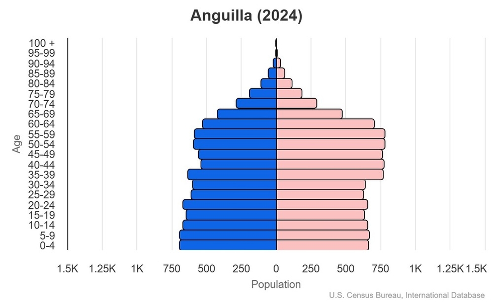
Population
total: 19,416 (2024 est.)
male: 9,107
female: 10,309
comparison rankings: total 219; male 219; female 219
Nationality
noun: Anguillan(s)
adjective: Anguillan
Ethnic groups
African/Black 85.3%, Hispanic 4.9%, mixed 3.8%, White 3.2%, East Indian/Indian 1%, other 1.6%, unspecified 0.3% (2011 est.)
note: data represent population by ethnic origin
Languages
English (official)
Religions
Protestant 73.2% (includes Anglican 22.7%, Methodist 19.4%, Pentecostal 10.5%, Seventh Day Adventist 8.3%, Baptist 7.1%, Church of God 4.9%, Presbyterian 0.2%, Brethren 0.1%), Roman Catholic 6.8%, Jehovah's Witness 1.1%, other Christian 10.9%, other 3.2%, unspecified 0.3%, none 4.5% (2011 est.)
Age structure
0-14 years: 20.8% (male 2,056/female 1,992)
15-64 years: 67.5% (male 5,958/female 7,147)
65 years and over: 11.7% (2024 est.) (male 1,093/female 1,170)

Dependency ratios
total dependency ratio: 48.2 (2024 est.)
youth dependency ratio: 30.9 (2024 est.)
elderly dependency ratio: 17.3 (2024 est.)
potential support ratio: 5.8 (2024 est.)
Population distribution
most of the population is concentrated in The Valley in the center of the island; settlement is fairly uniform in the southwest, but rather sparse in the northeast
Urbanization
urban population: 100% of total population (2023)
rate of urbanization: 0.47% annual rate of change (2020-25 est.)
Major urban areas - population
1,000 THE VALLEY (capital) (2018)
Sex ratio
at birth: 1.03 male(s)/female
0-14 years: 1.03 male(s)/female
15-64 years: 0.83 male(s)/female
65 years and over: 0.93 male(s)/female
total population: 0.88 male(s)/female (2024 est.)
Infant mortality rate
total: 3 deaths/1,000 live births (2024 est.)
male: 3.9 deaths/1,000 live births
female: 2.1 deaths/1,000 live births
comparison ranking: total 208
Life expectancy at birth
total population: 82.6 years (2024 est.)
male: 80 years
female: 85.3 years
comparison ranking: total population 26
Gross reproduction rate
0.85 (2024 est.)
Drinking water source
improved:
total: 97.5% of population
Physician density
1.51 physicians/1,000 population (2018)
Currently married women (ages 15-49)
46.1% (2023 est.)
Education expenditure
2.5% of GDP (2022 est.)
10.3% national budget (2024 est.)
comparison ranking: Education expenditure (% GDP) 174
Environment
Environmental issues
inadequate potable water
Climate
tropical; moderated by northeast trade winds
Land use
agricultural land: 0% (2022 est.)
arable land: 0% (2018 est.)
permanent crops: 0% (2018 est.)
permanent pasture: 0% (2018 est.)
forest: 61.1% (2022 est.)
other: 38.9% (2022 est.)
Urbanization
urban population: 100% of total population (2023)
rate of urbanization: 0.47% annual rate of change (2020-25 est.)
Government
Country name
conventional long form: none
conventional short form: Anguilla
etymology: in 1493, Christopher COLUMBUS named the island Anguilla, meaning "eel" in Spanish, because of the island's elongated shape
Government type
parliamentary democracy (House of Assembly); self-governing overseas territory of the UK
Dependency status
overseas territory of the UK
Capital
name: The Valley
geographic coordinates: 18 13 N, 63 03 W
time difference: UTC-4 (1 hour ahead of Washington, DC, during Standard Time)
etymology: name may derive from the capital's location among several hills
Administrative divisions
none (overseas territory of the UK)
Legal system
common law based on the English model
Constitution
history: several previous; latest 1 April 1982
Suffrage
18 years of age; universal
Executive branch
chief of state: King CHARLES III (since 8 September 2022); represented by Governor Julia CROUCH (since 11 September 2023)
head of government: Premier Cora RICHARDSON-HODGE (since 27 February 2025)
cabinet: Executive Council appointed by the governor from among elected members of the House of Assembly
election/appointment process: the monarchy is hereditary; governor appointed by the monarch; following legislative elections, the governor usually appoints the leader of the majority party or majority coalition as premier
Legislative branch
legislature name: House of Assembly
legislative structure: unicameral
number of seats: 11 (7 directly elected, 2 appointed, 2 ex-officio members)
electoral system: plurality/majority
scope of elections: full renewal
term in office: 5 years
most recent election date: 6/29/2020
parties elected and seats per party: APM (7); AUF (4)
percentage of women in chamber: 27.3%
Judicial branch
highest court(s): the Eastern Caribbean Supreme Court (ECSC) is the superior court of the Organization of Eastern Caribbean States; the ECSC is headquartered on St. Lucia and consists of the Court of Appeal -- headed by the chief justice and 4 judges -- and the High Court with 18 judges; the Court of Appeal travels to member states on a schedule to hear appeals from the High Court and subordinate courts
judge selection and term of office: Eastern Caribbean Supreme Court chief justice appointed by the British monarch; other justices and judges appointed by the Judicial and Legal Services Commission; Court of Appeal justices appointed for life with mandatory retirement at age 65; High Court judges appointed for life with mandatory retirement at age 62
subordinate courts: Magistrate's Court; Juvenile Court
Political parties
Anguilla Progressive Movement or APM; (formerly Anguilla United Movement or AUM)
Anguilla United Front or AUF
Diplomatic representation in the US
none (overseas territory of the UK)
Diplomatic representation from the US
embassy: none (overseas territory of the UK); alternate contact is the US Embassy in Barbados [1] (246) 227-4000
International organization participation
Caricom (associate), CDB, Interpol (subbureau), OECS, UNESCO (associate), UPU
Independence
none (overseas territory of the UK)
National holiday
Anguilla Day, 30 May (1967)
Flag
description: blue, with the UK flag in the upper-left quadrant and the Anguillan coat of arms centered on the outer half of the flag; the coat of arms shows three orange dolphins in an interlocking circular design on a white background, with a turquoise-blue field below
meaning: the white on the coat of arms stands for peace; the blue base for the sea, faith, youth, and hope; and the three dolphins for endurance, unity, and strength
National symbol(s)
dolphin
National coat of arms
the Anguillan coat of arms features three interlocking dolphins jumping out of seawater; they represent endurance, unity, and strength, and their circular motion stands for continuity; the white background symbolizes peace and tranquility, and the turquoise-blue base represents the sea, as well as faith, youth, and hope

National anthem(s)
title: "God Bless Anguilla"
lyrics/music: Alex RICHARDSON
history: local anthem, adopted 1981
_____
title: "God Save the King"
lyrics/music: unknown
history: official anthem, as an overseas UK territory
Economy
Economic overview
small, tourism-dependent, territorial-island economy; very high public debt; COVID-19 crippled economic activity; partial recovery underway via tourism, benefitting from its high amount of timeshare residences; considering reopening oil refinery
Real GDP (purchasing power parity)
$362.499 million (2024 est.)
$345.238 million (2023 est.)
$336.924 million (2022 est.)
note: data in 2015 dollars
comparison ranking: 213
Real GDP per capita
$31,000 (2024 est.)
$28,900 (2023 est.)
$27,400 (2022 est.)
note: data in 2015 dollars
comparison ranking: 77
GDP (official exchange rate)
$452.73 million (2024 est.)
note: data in current dollars at official exchange rate
Inflation rate (consumer prices)
3% (2022 est.)
1.8% (2021 est.)
-0.5% (2020 est.)
note: annual % change based on consumer prices
comparison ranking: 92
Agricultural products
small quantities of tobacco, vegetables; cattle raising
Industries
tourism, boat building, offshore financial services
Budget
revenues: $81.925 million (2017 est.)
expenditures: $72.352 million (2017 est.)
note: central government revenues and expenses (excluding grants/extrabudgetary units/social security funds) converted to US dollars at average official exchange rate for year indicated
Exports
$7.9 million (2017 est.)
$3.9 million (2016 est.)
note: Data are in current year dollars and do not include illicit exports or re-exports.
comparison ranking: 212
Exports - partners
Chile 60%, Netherlands 8%, Brazil 5%, Hungary 4%, USA 4% (2023)
note: top five export partners based on percentage share of exports
Exports - commodities
packaged medicine, garments, vehicle parts/accessories, vaccines, cars (2023)
note: top five export commodities based on value in dollars
Imports - partners
Chile 50%, USA 27%, Botswana 15%, Japan 1%, Dominican Republic 1% (2023)
note: top five import partners based on percentage share of imports
Imports - commodities
poultry, copper ore, natural gas, refined petroleum, fish (2023)
note: top five import commodities based on value in dollars
Exchange rates
East Caribbean dollars (XCD) per US dollar -
Exchange rates:
2.7 (2024 est.)
2.7 (2023 est.)
2.7 (2022 est.)
2.7 (2021 est.)
2.7 (2020 est.)
Energy
Electricity access
electrification - total population: 100% (2020)
Communications
Telephones - fixed lines
total subscriptions: 6,000 (2021 est.)
subscriptions per 100 inhabitants: 38 (2021 est.)
comparison ranking: total subscriptions 198
Telephones - mobile cellular
total subscriptions: 26,000 (2021 est.)
subscriptions per 100 inhabitants: 170 (2021 est.)
comparison ranking: total subscriptions 212
Broadcast media
1 private TV station; multi-channel cable TV subscription services are available; about 10 radio stations, one of which is government-owned (2024)
Internet users
percent of population: 81.6% (2021 est.)
Broadband - fixed subscriptions
total: 5,000 (2018 est.)
subscriptions per 100 inhabitants: 35 (2018 est.)
comparison ranking: total 195
Transportation
Military and Security
Military - note
defense is the responsibility of the UK